
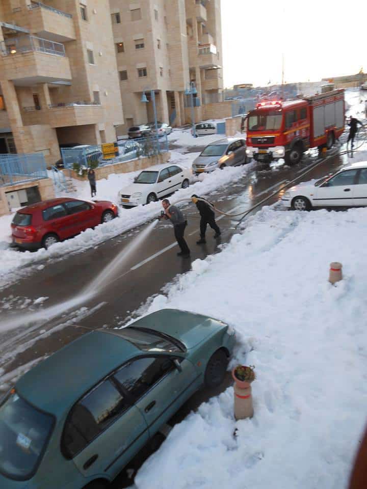
Israel is gearing up for another global warming climate change thank you Al Gore spectacular snow #Shelegedon #Snowpocalpyse EVENT of a lifetime (though only if you were born after last years event of a LIFETIME!). And who could forget some of the joyous sights of last year here and my personal favourite: clearing snow with water before the next freeze.
We already brought you the plans of the mayor of Jerusalem, who’s going to shut the city in advance of the anticipated snow.
I recently found the following Jerusalem Forecast Facebook page maintained by a very talented meteorology hobbyist. He gives the best explanations of what the forecasts are saying I’ve seen in a long time so I’m reproducing his most recent post here with permission:
Latest Forecast (Monday night Jan. 5, 2014): Heavy snow warning in effect with possible Blizzard conditions Wednesday night. Snow will likely return Thursday night into Friday.
Good evening everyone: It is remarkable what type of shift can occur in just a day in weather – and this time it’s a monumental one for all you snow lovers out there. Just yesterday the most snow I could see possibly accumulating in Jerusalem by the end of this storm was 10 inches. Now, it’s possible that the max amount could be higher…
As mentioned in my previous forecast, we are now close enough to the storm for the short range models to provide their valuable input in conjunction with the long range models. If you did not read my previous post about the difference between short and long range models, I am encouraging you now to do so.
Here is what we are currently seeing:
Tuesday into Tuesday night: The day will start off with mild temps similar to today, but noticeably windier. By the afternoon, the winds will become very strong, with gusts possible up to 40 mph, and temps will begin to fall rapidly. At this point, we’ll begin to experience the power of the trough we’ve been discussing for the past couple of days. Spotty rain showers may occur throughout the day.
Wednesday: This is storm day. Currently, it’s still a little unclear whether the snow will start in the morning or afternoon. I am expecting the real deal to start around 12 pm and get heavier as the afternoon progresses. By the night between 6pm-12am a full out blizzard may be in effect (no joke). Winds are currently forecasted to be very high at this time, with gusts anywhere between 35-45 mph, and the snow will be falling very heavily. This will be the prime time for orographic lifting (see previous forecast) and the city should come to a standstill.
Thursday morning into the afternoon: Some models, such as the latest Euro, are now showing that well into Thursday the snow will still be able to continue to fall moderate to heavy, and finally decrease in intensity after 12pm. However, light snow possibly mixing with rain is still forecast to fall the of the day and temps will remain very cold.
At this point, I expect accumulations to be between 10-14 inches, with locally heavier amounts.
Traveling Wednesday in and out of the city will likely be impossible by Wednesday morning since I read that the mayor plans on shutting down the entrance to Jerusalem before the snow begins. Inside the city, travel will become next to impossible all throughout the afternoon and night. Due to the snow forecasted to continue into Thursday, I expect this traveling situation to possibly continue into Thursday afternoon.
And just when you thought it was over…
Thursday night into Friday: There is still uncertainty to this event. However, models are now more consistently showing a resurgence of snow at this time. The trough is forecasted to redevelop, which will reestablish a north to south wind flow bringing cold air back into the area. As a result, most of the precipitation that occurs should fall as snow. The snow won’t be as heavy or as intense as what we will see Wednesday, but by Friday afternoon another 2-3 inches is possible. Trends have only increased over time, so this number could increase. This also means that currently, it is hard to determine just when the travel situation in Jerusalem will improve – we’ll have to keep monitoring this and of course, I’ll keep you updated.
And there you have it folks. What did appear to be more of a mix between the Jan 2013 and Dec 2013 storm, as I mentioned two forecasts ago, seems to have now turned into a beast that is inching closer to rivaling that last Dec 2013 storm. This is truly unprecedented considering that such storms in Jerusalem usually occur once every decade.
My prayers for snow since I moved here 4 years ago must be working I guess
Good night and stay tuned for more updates! -JH