
I and others here at Israellycool have written a lot about bias and anti-Israel lies in the media. MSNBC’s Kate Snow, however, has topped anything I’ve seen so far in a report on Friday in which she featured a series of maps created by anti-Israel hucksters that simply has no connection to fact or history.
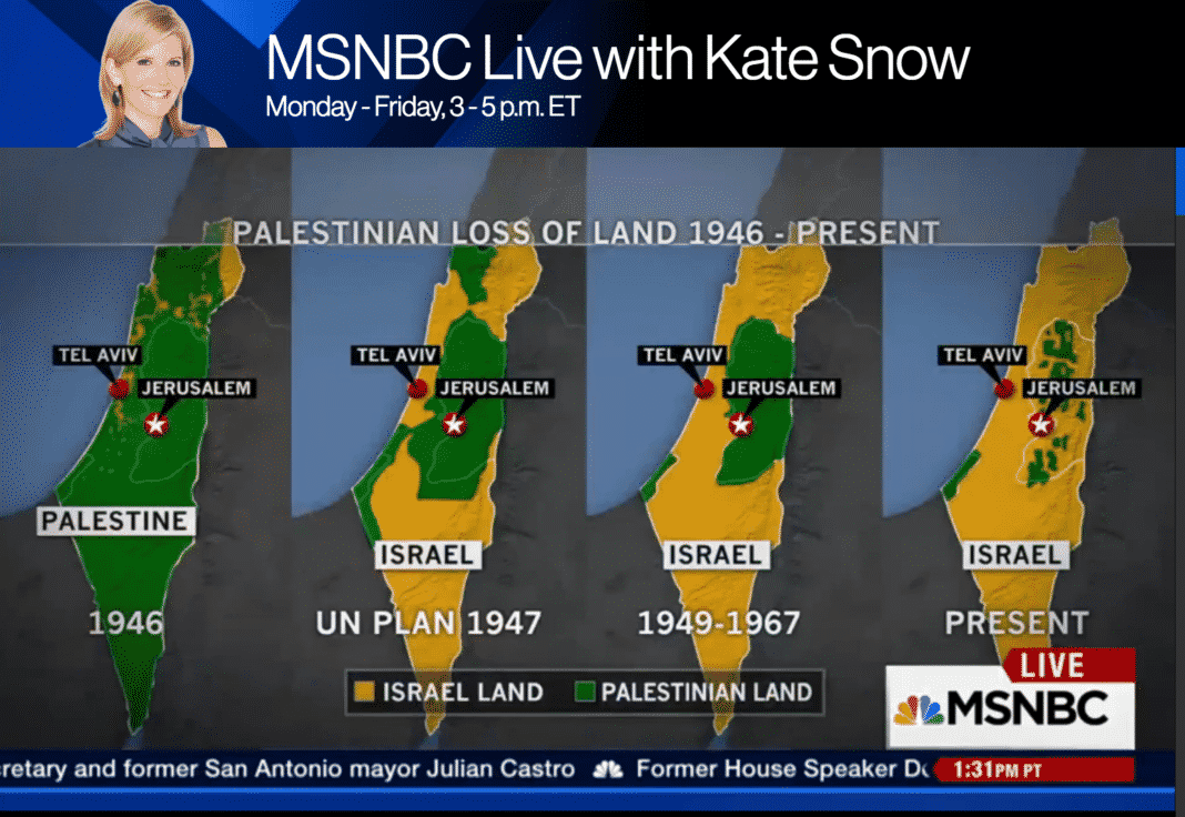
With the above image onscreen, Snow said, “We have a map that shows historically the areas that used to be Palestine in 1946, and then the UN plan there, and then as it shrunk down to basically Gaza and the West Bank, and the present, so what does that show you Martin, that the area where Palestinians are living, has it grown increasingly smaller?” Her alleged “expert,” Martin Fletcher, rather than correct her, responded, “Well absolutely, of course, this is what it’s all about, it’s about the land, and what this map shows you, and it’s pretty shocking when you present it in this way. . . .”
The only thing shocking is that MSNBC has become so unhinged from truth and facts, as to make it impossible to continue to call it a “news station.”
On Saturday morning the segment was available on Snow’s section of the MSNBC website, however, in an apparent admission of colossal stupidity, she seems to have removed it. Here’s a clip from YouTube:
https://www.youtube.com/watch?v=43rw4DJGUUA
Anyone with the slightest knowledge of the region knows that the first map is nothing more than a fairy tale, and that the other three are gross misrepresentations, but for those who need some remediation, the entire series has been thoroughly debunked by Shany Mor in The Tower. Mor explained:
The first [map] is by far the most dishonest of the lot. As far as I have been able to determine, it is based on a map of Jewish National Fund (JNF) land purchases dating roughly from the 1920s. The JNF was founded to purchase land for Jewish residents and immigrants in then-Palestine, and was partly funded through charity boxes that were once found in almost every Jewish school and organization in the West. Ironically, this map often adorned those ubiquitous boxes. . . .
The deceptive use of JNF land and only JNF land as a proxy for the entire Palestinian Jewish presence is but a trifle compared to the epic lie represented by this map: It deliberately conflates private property with political control.
They are not at all the same thing. The simple fact is that none of pre-1948 Palestine was under the political authority of Arabs or Jews. It was ruled by the British Mandatory government, established by the League of Nations for the express purpose of creating a “Jewish National Home.” It was also—contrary to the claims of innumerable pro-Palestinian activists—the first time a discrete political entity called “Palestine” existed in modern history. And this entity was established in order to fulfill a goal that was essentially Zionist in nature.
But this lie is compounded by another that is even more epic in scope: Labeling every single patch of land not owned by the JNF as Arab or Palestinian. This was quite simply not the case. We have incomplete data on land ownership in modern Palestine, and even less on Arab property than Jewish property, partly due to the very complicated nature of property law in Ottoman times. But anyone’s map of private property in Mandatory Palestine from this period would be mostly empty—half the country is, after all, desert. It would show small patches of private Jewish land—as this map does—alongside small patches of private Arab land, as this map shamelessly does not.
Mor explains that the second map represents the UN partition plan that was never implemented because it was rejected by the Arabs in favor of war. He then continues:
[In 1948], with partition rejected by the Arabs and no help from the international community in sight, the Jews declared independence and formed what would become the Israel Defense Forces. The Arab states promptly launched a full-scale invasion, whose aims—depending on which Arab leader you choose to quote—ranged from expulsion to outright genocide. And the Arabs lost. At war’s end in 1949, the situation looked roughly like the third map in the series—the first of the lot that even comes close to describing the political reality on the ground.I say “close” because it too is remarkably dishonest. It is only because one’s standards of dishonesty have been stretched so far by its predecessors that it almost seems true. But, alas, it is not. The map is dated 1967. What it shows are the so-called “armistice lines,” i.e., the borders where the Israeli and Arab armies stopped fighting in 1949. These lines held more or less until 1967. As far as Israel’s borders are concerned, then, the map accurately presents the situation over those 19 years.
But what lies on the other side of the line, in the territories that are today called the West Bank and the Gaza Strip, is again presented in radically dishonest fashion. These lands were not—not before, during, or after 1967—“Palestinian” in the sense of being controlled by a Palestinian Arab political entity. Both territories were occupied by invading Arab armies when the armistice was declared in 1949, the Gaza Strip by Egypt and the West Bank by Jordan. The latter was soon annexed, while the former remained under Egyptian military administration. This status quo lasted until 1967, when both were captured by Israel.
The first three maps . . . confuse ethnic and national categories (Jewish and Israeli, Arab and Palestinian), property and sovereignty, and the Palestinian national movement with Arab states that ruled over occupied territory for a generation. They are a masterpiece of shameless deception. . . .
As we move to the fourth map, shameless deception is the only thing that remains consistent. This map, usually labeled either 2005 or “present,” purports to show the distribution of political control following the Oslo process and the Israeli withdrawal from Gaza. The patches of Palestinian land in the West Bank are areas handed over to the Palestinian Authority in the 1990s, mostly under the 1995 Oslo II agreement. Expanding upon the autonomy put in place after previous agreements in the Oslo process since 1993, this agreement created a complex patchwork of administrative and security zones, splitting the West Bank into areas of exclusive Palestinian control, joint control, and Israeli control. It was meant as a five-year interim arrangement, after which a final status agreement would be negotiated.
Final status talks did indeed take place. But no agreement was reached. As in 1947, the principal reason was Palestinian rejectionism.
Read Mor’s entire article for his description of what an honest map would like.
Snow and her so-called expert appeared oblivious to all of the above. This report, of course, followed Ayman Mohyeldin’s egregious misreporting last Wednesday on the same network. While MSNBC has always been seen as having a specific political point of view, there is no excuse for its failure to report accurately.
Although I’m not familiar with this “journalist,” based on Snow’s website she appears to spend much of her time reporting on the Kardashians and celebrity drug overdoses. If she’s not willing to stick to those subjects in the future, NBC should fire her so that she can go back to the Enquirer. In the meantime, in addition to removing the segment from its website, it should immediately issue an on-air correction and apology.
Update, October 18: The Washington Free Beacon reports that MSNBC now admits the graphic was “factually wrong,” and that Kate Snow and Martin Fletcher will be retracting it on-air on Monday. Adam Kredo quoted a spokesperson for the network saying that Snow and Fletcher “will address the map in a segment Monday about agendas and disinformation on both sides of the Israeli-Palestinian conflict.” On both sides . . . the retraction may prove as interesting as the initial faulty reporting.
Update, October 19: I found Snow’s retraction adequate but underwhelming. She said that “we showed a series of maps to show the changing geography in that region. We realized after we went off the air, the maps were not factually accurate and we regret using them.” It seemed an odd choice, though, to call on the very same expert, Martin Fletcher, “to help clarify.” Fletcher said that the first map was “completely wrong” because there was no Palestinian state in 1946. He also said, a little bit later in the segment, that the question of how to stop the violence has been a question since Israel was founded and “Arabs didn’t agree with the founding of the state” (an interesting word choice). He neglected to mention, however, that the third map depicted areas under Jordanian and Egyptian control, and that the final map showed the first time ever that Palestinians had self-rule in the area. In discussing the current violence, he also still failed to mention Abbas’s incitement, nor did either of them explain how the incorrect map came to be shown.