There was a plethora of news and op-eds about recent Israeli approval of housing projects in and around Jerusalem. After we schooled the main stream media about their slanderous reporting on E-1, it’s time to deal with the others.
Ramat Shlomo:
Ramat Shlomo was built in the 1990’s, on a JNF forest that demarcated the outline of the Jordanian occupation of the Jerusalem hinterland. The new housing project in the neighborhood is planned on the southern slope of the hill, on a sliver of land locked between the current buildings and a major highway.
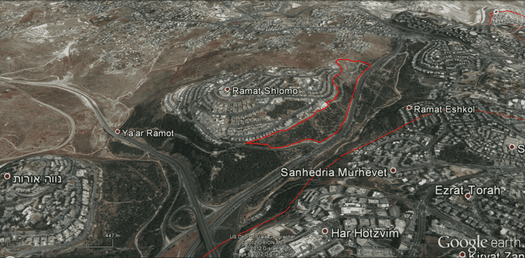
Needless to say, this expansion of some 1500 housing units is not only inside Jerusalem municipal lines, it doesn’t encroach on any field or pasture.

Furthermore, even the far left Geneva Initiative lists Ramat Shlomo as being inside Israeli territory in the event of a future land swap.
And as a prelude to the errors to come, this is the image the BBC used to portray Ramat Shlomo. That isn’t Ramat Shlomo, but Ramot, which eastern edge can be seen in the previous image. Per BBC, it’s all the same, just like Nottingham and Birmingham, both are inghams.
Giv’at Hamatos
Literally hill of the air-plane, where on June 6, 1967, an IAF plane was shot down by occupying Jordanian forces. It is located on the southern edges of Jerusalem, and is currently the site of caravan houses for Ethiopian immigrants, and has long since been on the planning board.
This is how clueless Harriet Sherwood reported it:
Givat Hamatos, across the pre-1967 Green Line between southern Jerusalem and Bethlehem, will be the first new discrete settlement created since 1997. Critics say it will become part of a chain of settlements in the area, further impeding access between the two biblical cities.
European diplomats in Jerusalem have warned that the construction of Givat Hamatos is a “game-changer” which could destroy the chance of a viable Palestinian state with East Jerusalem as its capital. A diplomatic source said the approval of the new settlement was “a devastating development for all those who believe in a two-state solution”.
Sherwood and others clearly didn’t even open a map to see where it is. If they did, they would’ve seen that: A) the access between Jerusalem and Bethlehem will not be changed, and B) that the area is in no means an empty desert (unlike E-1), and that the division between Jews and Arabs in it, are already a fact on the ground, never mind any future development.
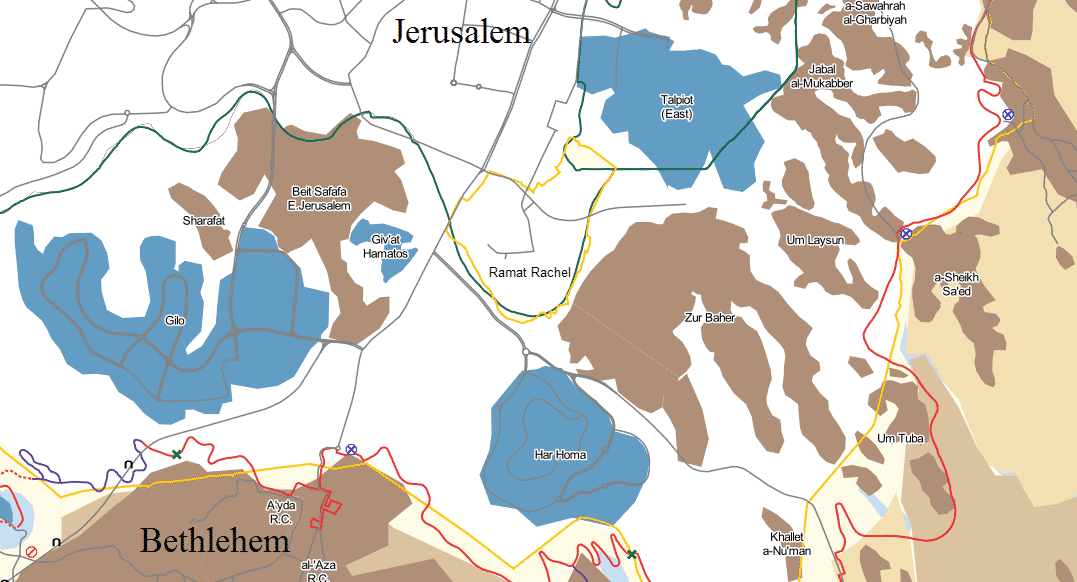
As you can see in the above map, courtesy of B’Tselem, Giv’at Hamatos is engulfed by the Arab neighborhood of Beit Safafa from the north, west and south, while on the east, there’s road 60 – the millennia old path between the cities, and Kibbutz Ramat Rachel. The 500 meter gap between Beit Safafa and Ramat Rachel, were the main road passes through, also houses the southern public transport hub of the Jerusalem metropolitan area.
So in the current state of affairs, it’s in no way a “game-changer” that threatens the viability if a future Palestinian state. But build 2600 apartments, with some 600 intended as an expansion of Beit Safafa that doesn’t change anything that doesn’t already exist, and all of a sudden you have a powder keg. The planned expansion is roughly 0.3 Km2, making it 0.004% of their intended state. It’s not about the viability of it, it’s about Jerusalem.
B’Tselem and BBC fail Geography
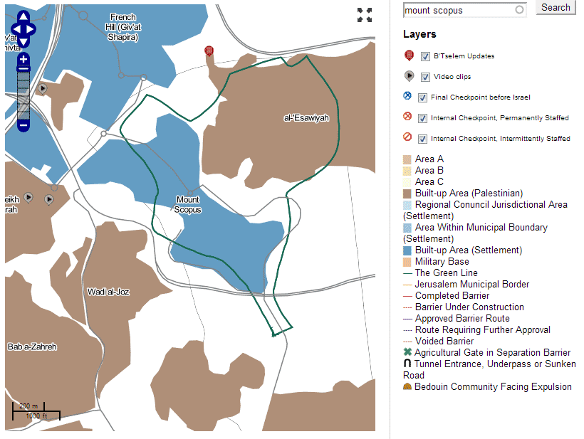
I saw the aforementioned failed BBC article a few days ago, but didn’t have time to write about it. What struck me more, apart for the wrong picture, was the inclusion of The Hebrew University Mount Scopus campus in the settlement blocs.
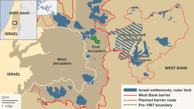
The BBC simply erased the Israeli exclave that existed there during the Jordanian occupation between 1948 to 1967, and relabelled the university campus and Hadassah hospital, two renowned institutions there since the early 20th century.
Serendipity has its ways, and Jessica Montell of B’Tselem tweeted their online map:
Where exactly did Israel just approve 2,600 new homes? See Giv’at Hamatos on B’Tselem’s interactive map: btselem.org/map?title_op=c…
— J Montell, B’Tselem (@JessicaMontell) December 19, 2012
This interactive map has the exact same layers as the BBC, including university and hospital as settlement, but does indeed demarcate the Israeli exclave on mount Scopus.
I can assume, that just like the EU clerk misused the intersection tool, so too did the group or company responsible for the BBC’s and B’Tselem’s geographic data.
Old City of Jerusalem
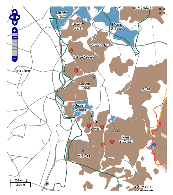
Another one of those “settlements” listed in the BBC’s and B’Tselem’s maps is the Jewish quarter in old Jerusalem.
Yes, that’s right, per B’Tselem and BBC, the millennia old Jewish presence in Jerusalem is but a footnote to the 19 years of Jordanian apartheid and ethnic cleansing of Jews from Jerusalem.
Update: I pointed out the Mt. Scopus error to Jessica Montell last week, and today as well, and she promised it’s being corrected. We’ll wait and see.
@judgedan48 @hebrewu Yes, it’s being corrected in the next version of the map. It’ll take a few weeks. Thanks
— J Montell, B’Tselem (@JessicaMontell) December 29, 2012


